It's taken three weeks, but I am finally finishing up the
chronicle of a two week vacation I took over the holidays. 2050
kilometers ( 1250 miles), About 70 hours of driving and 20 fuel
stops. It was time to bring the motorbike to near Yangon. I was off
to Dala, a town across the Yangon River from Yangon itself. One of my
co-workers had family there, and they'd agreed to allow me park my
bike there, and I agreed to pay them a nominal rent for the space.
The problem was that I was running out of money. I still had
plenty of US dollars in my bag, but on the morning of the last day, I
had 7000 Kyats in my wallet ($5). Enough for food and gas, but what
about the rent I'd promised?
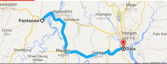
Surely, somewhere along the 121 kilometers of Pantanaw to Dala,
there would be a bank or money changer where I could pick up some
Kyats. Barring, that, I could use my ATM card to draw from my Thai
bank account.
My first hope was the Pantanaw itself. Nope. Although there was a
bank in town, they weren't licensed to exchange currency. Next was
the larger town of Nyaungdon. I found a bank there, but no one spoke
English in it, so I had to rely on my carefully memorized Myanmar
phrase “do you exchange money?”. I was told by the receptionist
to have a seat and so I felt I had found the place. I sat there for
45 minutes until they found the one guy who knew a few sentences of
my language to explain that no, they do not exchange currency. I'd
have to go to Yangon for that.
The Irrawaddy River after it's broken off into multiple streams in one of the largest deltas in the world.
I need to give Nyaungdon another chance. It looks like an
interesting town and it's an easy motorbike ride away from Yangon.
Maybe next weekend.
See, it's convenient that I've finished up the Myanmar Motorcycle
Journey series tonight as it is also my first day of my next
vacation! As I've said before, that's one of the things I like most
about working here: copious amounts of time off. I don't have to work
for another 8 days.
Tomorrow, I've got an early flight for Kuala Lumpur, Malaysia.
It's time for another border crossing so as to renew my work visa
here. I'll only be in KL for 3 days; as I'd spent a lot on the
motorcycle journey, and so I don't need another expensive vacation
this close to the last one. Now, in April, I get a month off, and I'm
not sure what I'm going to do for that.
Enjoy the video. The last of the ukulele themed vids.
After three glorious days relaxing on the beach and Chaungthar, the vacation was winding down and it was time for me to head back towards Yangon. If I'd made the 250 km journey home in one leg, it probably would've taken me about 8 hours driving on what I anticipated would be pretty good roads. After all I'd done the last two weeks, another long leg wouldn't have been prohibitively taxing.
But why bother? I was ahead of schedule, even after adding an additional stop, and so I decided to break this leg into two. If you remember from my initial itinerary, I had originally planned that my final destination was going to be Naypyitaw, and that was definitely going to take two days. Instead, I had found a co-worker who has family just on the outskirts of Yangon (where motorcycles are forbidden), and I'd arranged a place to park outside of town. In any case, since it was going to take me two days to get to NOT, why not make it two to Yangon?
I scanned my Google maps for an appropriate halfway point. There had to be a town somewhere along the way that was big enough to have a guesthouse or two. I decided on Pantanaw. In researching the place, I found out something interesting. Pantanaw is the home town of perhaps the second-most-famous Burmese person in history! After Aung San Suu Kyi, when it comes to Myanmar, there's no one more well known that U Thant (I would call him Mr U Thant, but as "U" means "mister" in Burmese, that'd be kinda redundant). As you may know, U Thant was the Secretary General of the United Nations for most of the 1960's; he was a statesman for the world. Ironically, he wasn't well liked by the ruling military junta here at the time, but since he was SecGen and not just an ambassador, he couldn't be recalled. Secretary Thant's grandson, Thant Myint U, is now a bit of a celebrity himself. He's written some great books about Myanmar is a leading advocate for change here. Maybe, when I got to Pantanaw, I could look for signs of U Thant like I looked for signs of Pascal Htoo Thwe in Pekon.
By the river in Pathein
First though, I traveled through Pathein, formerly known as Prome. As you'll hear in the video, Pathein is the capital and largest city in Myanmar's Ayerwaddy region. I lingered long enough to check out the river Pathein and a pretty impressive Pagoda in town.
On the road to Pantanaw, I had another problem with the motorbike. Actually, it was the same problem I'd had a week ago or so in Pyay: the horn stopped working. As I said then, there's perhaps no more important piece of equipment while driving a motorcycle in Asia than the horn. It's used constantly.
I went looking for a motorbike mechanic in Pantanaw. Found one. The cost the repair? $1.50 for a new horn. 40 cents in labor for the guy to install it.
What I didn't find was a statue of U Thant. I didn't find anything that indicated "U Thant House this way". Or maybe I did. THing is, this far off the beaten path in Myanmar, none of the signs have any English. Heck, even my guesthouse, which I I had gotten a picture of on Facebook before leaving) didn't even say "Guesthouse" in English. I tell you Pantanaw, being halfway between Yangon and the coast, has potential as a tourist attraction. They just gotta develop.
In case you haven't noticed, the new
camera is waterproof.
The vacation was winding down and I had pretty much run out of road. My next destination was to go home to Yangon, but before I did, I had three wonderful days at the beach resort town of Chaungthar.
I seem to be missing a bunch of video from my exploration of the town of Chaungthar itself. That's all right. The town was interesting, but crowded and dirty, especially since I was there during the first weekend of 2016 and the place was packed with local tourists from Yangon.
I'd been told not to miss the beaches north of town, so on my second day, I took the bike up the road to see where it would lead. I drove all the way to Shwetaungyan where the road ended at a river and a rickety looking boat ferried people across.
Yes, the beaches north of Chaungthar are not to be missed. Not only are they beautiful with soft white sands and warm clear water, but they're also empty. You get them all to yourself. That's nice, but at the same time, I for one like a beach chair. Maybe a beachfront restaurant with cold beverages. The beaches near Shwetaungyan have got that too! Well, at least a couple of them do.
I'd spent $130 for one nigh of lodging in Ngapali the day before. 24 hours later,
on the same coast, on as spectacular of a beach, I spent $6 for a
night at the only guesthouse I could find in the town of Gwa. You might
think, at that price, I might want to linger in Gwa. As you saw in
the last video, there's a white sand tropical beach there,
something I'd be driving towards and longing to spend some time at
since I left the mountains of eastern Myanmar.
See, thing is, there is a point at which the seclusion, privacy and virginity of a tropical beach becomes inconvenient. If there was
one shop, one place I might get a cold drink or a coconut, a single
touristy thing on the whole beach, I might have stayed in Gwa for
another day or more. But no. The beach was beautiful, but without amenities. If you want ULTIMATE isolation on a tropical beach, go
to Gwa. Me, I wanted a beach chair and some restaurants.
Then, there was the quality, or lack thereof, of the guesthouse.
At $6/night (and that was for a room with two beds), I can't expect
much. But a 1 inch thick mattress, one electrical outlet, shared bathrooms in the most
mold-filled bathroom I've ever experienced (what would it take for them
to scrub the damn thing?!?) and no power before 4 PM and none after
11 PM, in my mind, the More Guesthouse and Gwa quickly lost all the
attraction that their really cool sounding names initially drew me. I
can't
No power? No problem! My motorcycle has its own
USB port for recharging portable devices.
recommend Gwa. Until there's some development there, a neat
name is all it has going for it.
Yeah, no power after 11 PM, anywhere in town. It was New Years
Eve. I was asleep in my crappy room at the turn of 2016.
And so, in the morning, I left Rakhine State and the ancient
kingdom of Arakan. I've studied the peculiar situation of Myanmar and
it's ethnic groups since I've been here, and found it weird that
one of the longest standing conflicts in the country has been between
the Burmese (the Bamar, the dominant ethnic group in the middle part
of the country and 60% of the overall population) and the people of
Rakhine State. These folks have so much in common. Why is there separatism? The language, religion, customs, celebrations and
foods of the Rakhine are almost identical that of the Bamar, but yet,
for in the 60 years of independence from the colonial poweres,
there's been continuing resistance by the coastal folks against their
cousins on the other side of the hills. I guess it comes down to
history. See, for hundred of years, the Arakan Kingdom was entirely
separate from the Burmese court at Mandalay. It wasn't until the
British came in the 19th century when the British conquered both
kingdoms that they were united in any way, forcibly so under colonial rule.
The old Arakan and Burmese
kingdoms, circa 1700
Things are quiet where I
was; the resistance now is via a local political party, but a few
hundred miles north, and the Arakan Army still fights against the
army of Myanmar.
Where to go from Gwa? This was my last planned stop on the
journey. I was going to spend a few days there, and then drive my
motorbike back to Naypyitaw to leave it where I had it stored before.
It was only about 40 miles down the coast, as the crow flies, from
Gwa to the twin resort towns of Ngwe Saung and Chaung Thar. If you've
been watching my videos from Myanmar these last 2 years, you may
remember I'd been to Ngwe Saung with Anthony and Patty back in April
of 2014. I really didn't want to go some place I'd been before, so
even though Chaung Thar has the reputation of being overcrowded and
dirty, onto Chaung Thar I went.
Gotta keep the good karma on the road.
Plus, the smiles are really cute.
40 miles as the crow flies was 150 miles on the roads. I had to
cross back over the coastal range, travel south into the Irrawaddy
Delta, and then back over the Rakhine Hills to Chaung Thar. It was a
lot longer drive than I thought, and I had my first mechanical
problems with my bike along the way.
Just north of Chaung Thar. One of the most beautiful places I've been in Myanmar.
Enjoy the Video.
Road Report:
Distance: 220 km
Travel time: 6 hours
Conditions: Good 70%; Fair 25%; Bad 5%
It was New Years Eve Day, the last day of 2015. I was being forced out of Ngapali, Myanmar's most exclusive beach resort. There were no rooms available; I hadn't made reservations. It was perhaps, a good thing as the room rates at Ngapali were ridiculously expensive in the high season.
So I was on the road again! My goal was Kanthayar
Beach, not that far from Ngapali as the crow flies, but the roads were fair at best. I had read online that there were several places to stay in Kanthayar, but I didn't have any specific places in mind.
As you'll see in the video, as I headed south, things sorta went south.
I found Kanthayar (eventually), but there was a surprise waiting for me there.
Ultimately, I ended up in Gwa.
You'll notice in several of the next few videos that I frequently stop and donate money
at the numerous roadside collection points. I figured I wanted the good karma.
At the beach
Road Report:
Distance: 200 km (should have been about 160)
Travel time: 6 hours
Conditions: Excellent 1%, Good 15%, Fair 70%, Bad 14%
I woke up in Pyay feeling good. I'd traveled further on my motorbike in the previous two days than during any two days in my long relationship with the iron horse. A bit sore, but all in all, my fat old body was holding up well.
It was time to cross the mighty Irrawaddy River and head towards Rakhine State and the coast. Two problems cropped up on the ride out of town. First off, finding the bridge entrance was harder than I'd thought. This whole trip would have been impossible without GPS and Google Maps on my phone.
There's the bridge!
The second problem was my mild gephyrophobia, a fear of bridges. Small bridges don't bother me. Walking over a bridge doesn't concern me. I'm not afraid it's going to collapse, and I'm okay with heights in general. Instead, it's driving on a tall, high bridge that scares the crap out of me. I have a bit of a panic attack in these circumstances. I have to stare at the pavement, slow down and focus. My arms and legs get weak. I want to close my eyes, but of course, I can't. As you'll hear in the video, singing helps too.
Just past the river, the Rakhine Hills cropped up right away. Scenic as the previous two ridges I had crossed, the hills presented little challenge as I had become adept at handling my little motorbike on these windy roads. As I've noted in previous blogs, the people I passed on the road were astounded to see a foreigner out in the countryside; few westerners come through here outside the confines of a tour bus or hired car.
The Arakenese, the people of Rakhine State
Passport, please.
I got stopped by the authorities for the first time on the journey. This was the first opportunity I had to test what I'd been told: by having a Myanmar Drivers License, I didn't need any special papers or permissions to travel throughout Myanmar. I was confident, but whenever you're stopped by the police in the developing world, you really can't be sure what's going to happen.
Turns out they were very nice. The served me a cup of coffee while they recorded my paperwork.
I made such good time on the road, I had reached my proposed destination of Toungup by 1:30. Although tired, I was really looking forward to reaching the beach and lounging on the warm, white sands of a tropical beach. Plus, if I got to Ngapali that day, I could spend two nights there and not have to travel at all the next day. So I pushed on!
It was the night before New Years Eve, and I didn't have a room reservation. I knew there were lots of hotels in Ngapali, so I wasn't too worried. I knew that accommodation was expensive in Ngapali, but I was willing to pay $60-75/night, about twice what I'd been paying per night on the trip thus far, so I wasn't too worried.
Yeah, no worries. I got the beach by sunset, and the only room I could find was twice the price I was hoping to spend.
I made it! Sunset over the Bay of Bengal
Enjoy the video!
Trip Report:
Distance: 250 km
Time: 7 hours
Road conditions: Excellent 2%; Good 30%; Fair 60%; Bad 8%
One impression I got regarding Myanmar as a whole while I tootled along these rural roads was how sparsely populated it is. So much natural, undeveloped land. Once you're in the valleys, there's plenty of people, but up in the hills I could sit on the side of the road, taking a break, and 10 minutes would go by without anyone passing through.
You may have noticed in previous vids, I did take a lot of breaks. I'd drive 45 or 50 minutes, and then spend 5 or 10 off the bike. Even with that, by the end of the 2000 mile trek, I had saddle sores.
Look at the size of that pig!
This stage of 212 km had me crossing my previous path, sort of a middle point in the big figure-8 I made in the country. Early in the vid, I cross under the New Mandalay Highway, which I had traveled on day 1 on the bus. Then it was up into the Bago Hills, the lowest of the 3 ranges I crossed in 3 days. These scenic hills, were dry and somewhat empty, a lot of it being taken up by a nature reserve.
Eventually, I descended into the river valley of the mighty Irrawaddy River, the lifeblood of the nation of Myanmar. Near Pyay, I made
a detour to see another city. An ancient city. A ruined city. Dug out of the fertile, brown soils by archaeologists some 30 years ago, the 2000-year-old city of Sri Ksetra fascinated me. I think that's most remarkable is that you can look around and see where half the city is still buried, marked by earthen mounds on the otherwise flat plain.
Enjoy the video!
Road report:
Distance: 212 km
Time: 6 hours
Road conditions: Excellent 2%; good 45%; fair 45%; bad 8% (see the key)